🏔️ Rurimeria Hill Moorland Trek — Aberdare Range, Kenya
Safari at a Glance
Wild Springs Adventures | Nyandarua County, Kenya
🌿 The Mountain That Earns Respect
There is a moment on Rurimeria when you crest what you think is the summit — lungs burning, legs shaking — and you see another ridge ahead. Then another. The false summits break more people than the altitude. But when you finally reach the true peak, when the wind hits, and you can see Mount Kenya's glaciers to the north and the Great Rift Valley falling away to the west, you understand why this hill is considered sacred ground.
The Maasai called it Olurumueria — named for the stubborn vegetation that clings to the summit where nothing else survives. At 3,860 metres above sea level, Rurimeria is the third-highest peak in the Aberdare Range and the best single-day high-altitude training hike you can do from Nairobi.
This is not a gentle walk. It is a full-day, leg-shaking, lung-testing commitment. It is also the trail our guides use to check if you are ready for Mount Kenya. Handle Rurimeria well and Point Lenana is within reach. Struggle here, and we know exactly what to work on before your next attempt.
Wild Springs Adventures has been guiding groups on this trail for years. Every detail — the early departure, the armed ranger, the firm turnaround rule — is there because experience taught us what works.
🎯The honest truth:
Rurimeria is one of the most carefully guided hikes from Nairobi, and one of the most humbling. The climb is steep from the very first kilometre. Altitude hits before you expect it. The false summits are mentally brutal the first time around. But the people who come prepared, pack the right gear, and trust the guide? They stand on that cairn with a feeling that almost nothing in a normal week can match. The Aberdare moorland in morning light, Mount Kenya on the horizon, the entire Rift Valley falling away below — that view is yours. The mountain doesn't negotiate. Come ready, or come back when you are.
📋 Rurimeria Trek at a Glance
| ⛰️ Summit | Rurimeria Hill, 3,860m (12,670ft) |
| 📈 Elevation Gain | ~955m (3,133ft) from trailhead |
| 📏 Distance | 14–18km round trip |
| ⏱️ Time on Trail | 7–10 hours |
| 📍 Trailhead | Gathuthi Primary School, Nyandarua County |
| 🗓️ Trailhead Altitude | 2,905m (9,531ft) |
| 💪 Difficulty | Strenuous — experienced hikers only |
| 🪖 Guide Requirement | Armed KWS ranger + certified guide — mandatory |
🕐The Full Day Rurimeria Hike — Hour by Hour
🚐 04:30 – 05:00 · Nairobi · Departure
The alarm is unkind. The coffee helps. You meet your Wild Springs guide at the pickup point, load into the tour van, and most people sleep through the first hour. The road north toward Nyandarua is dark and smooth. By the time you are properly awake, the Aberdare Range is already ahead of you.
📋 08:00 · Ndunyu Njeru, 2,905m · KWS Registration
The Kenya Wildlife Service office. Park fees paid. Your armed ranger collected. The last rough kilometre driven to Gathuthi Primary School. The mountain sits above you in morning mist. You lace your boots twice. You wish you had trained more. Everyone does.
🔌 08:30 · 2,905m · Through the Electric Fence
Ten minutes of flat walking. Then the fence — 400km of conservation boundary separating farmland from the Aberdare ecosystem. You cross through the gate. The bamboo forest closes around you immediately. The flat section is over.
🌿 09:00 – 11:00 · 2,905m → 3,200m · The Bamboo Zone
The trail goes up. And up. Dense bamboo, mud, decomposing leaves, stinging nettles that punish short sleeves. You gain 300 metres in 3.5 kilometres. Your heart rate stays high. The air is noticeably thinner than in Nairobi. You begin to understand what this mountain is.
⚠️ Mild headache and shortness of breath are normal here. Drink water. Slow your pace. Tell your guide if you feel nauseous — do not push through alone.
🌾 11:00 – 12:00 · 3,200m → 3,400m · The Heather Zone
The bamboo breaks. Suddenly, the air opens. Twisted trees draped in lichen, their branches gnarled and beautiful. The first real views arrive: Mount Kipipiri to the west. You eat something here. You need it for what comes next.
⚡ 12:00 – 13:30 · 3,400m → 3,600m · The Switchbacks The trail turns relentless. Zigzag after zigzag, each steeper than the last. You can see Geta village far below — too far. The air is noticeably thin. Legs feel heavy. This is where the false summits begin. You crest a ridge, see the top, hike toward it — then realise there is another ridge behind it. Then another.
⏰ If you have not reached 3,600m by 13:00, your guide will discuss turning back. The 15:00 turnaround rule is non-negotiable.
🌫️ 13:30 – 14:30 · 3,600m → 3,860m · The Moorland Push Bog.
Tussock grass that hides ankle-breaking holes. Giant groundsels that look like something from another planet. Trail markers fade — red paint on rocks, easy to miss in fog. Your gaiters are earning their keep. The wind picks up. Temperature drops to 6–12°C. You reach for your shell layer. Then suddenly, there is no more up.
🏆 14:30 · 3,860m · THE SUMMIT
If the weather holds, Mount Kenya's peaks to the north. The Rift Valley dropping 2,000 metres to the east. The Aberdare moorlands rolling south. You take photos. You eat lunch hunched against the wind. You feel exactly what you came for.
14:45 — mandatory descent begins.
No exceptions. Afternoon fog above 3,500m makes navigation dangerous.
⬇️ 15:00 – 18:00 · 3,860m → 2,905m ·
Descent Knees take their punishment. Bogs try to swallow boots. You move with purpose to stay ahead of the cloud line, back through the electric fence by 17:00.
Vehicle leaves by 17:30, Departure for Nairobi.
Nairobi by 20:00. You will sleep in the car. You will be sore tomorrow. You will already be thinking about when to come back.
🗺️ The Four Zones
🌿 Zone 1 · 2,905m – 3,200m · Bamboo Forest Dense bamboo, steep and wet. Stinging nettles demand long trousers. The forest is cool, but your body will be burning.
🌾 Zone 2 · 3,200m – 3,400m · Heather Zone: Twisted trees, lichen, and your first open views. A welcome recovery stretch before the switchbacks start.
⚡ Zone 3 · 3,400m – 3,600m · Switchbacks Steep zigzags, false summits, thin air above 3,500m. Mentally, the hardest section. The mountain tests your will here.
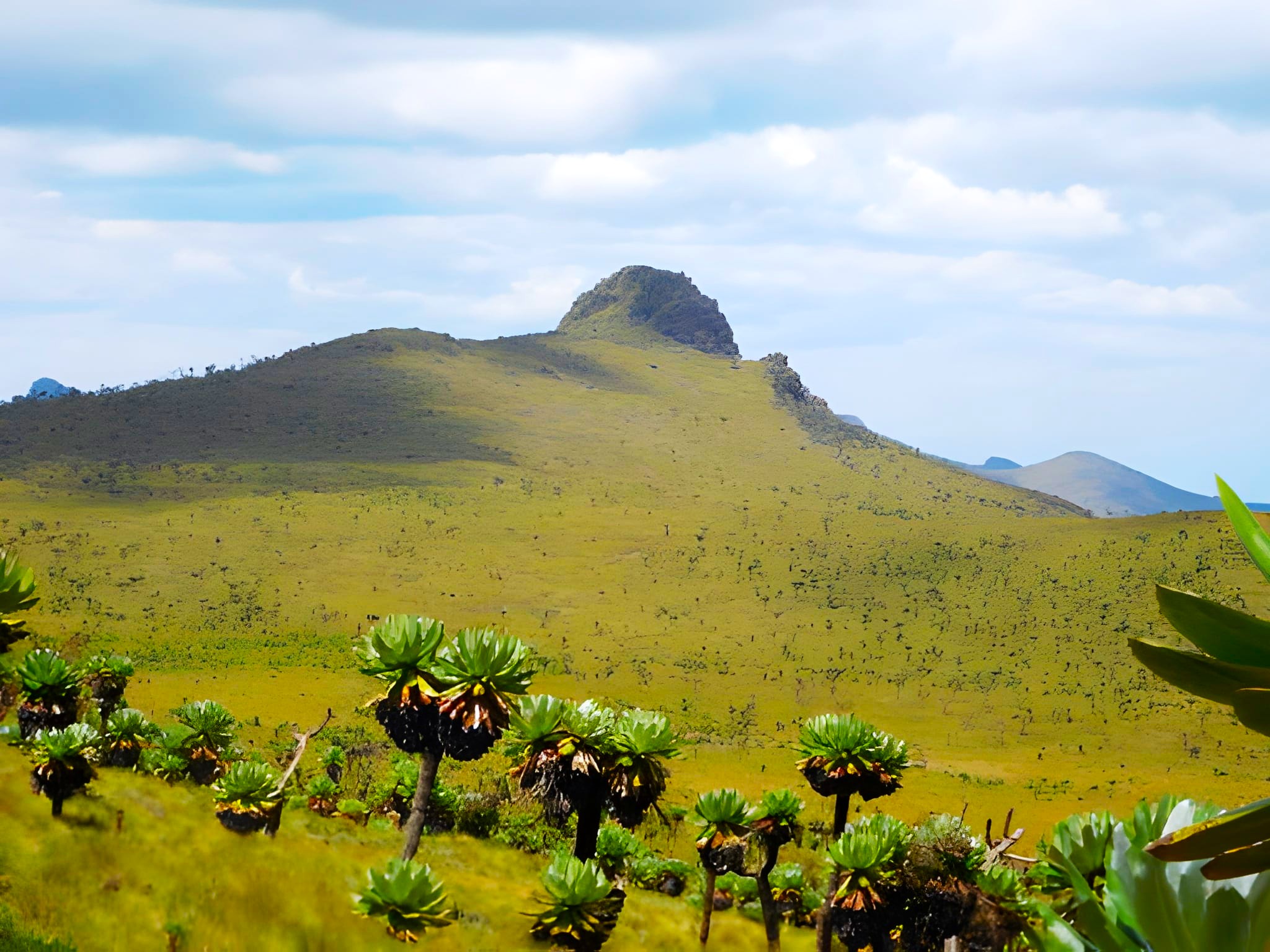
🌫️ Zone 4 · 3,600m – 3,860m · Afro-Alpine Moorland Bog, tussock grass, giant groundsels. Faded trail markers. Wind. Cold. The summit cairn at 3,860m. Everything you came for.
🦌Wildlife & Nature
The Aberdare Range is home to 290+ bird species and some of Kenya's most elusive animals. An armed KWS ranger accompanies every group — these animals are real and treated with full respect.
| Species | Sighting Likelihood | Where on Trail | Note |
|---|---|---|---|
| 🐘 Forest Elephant | ★★★☆☆ | Lower bamboo zone | Present and dangerous — why the armed ranger is mandatory |
| 🦬 Buffalo | ★★★★☆ | Bamboo zone, mornings | Common in lower sections, especially early |
| 🦌 Mountain Bongo | ★☆☆☆☆ | Dense forest | Fewer than 100 left in the wild. Seeing one is a lifetime moment. |
| 🐒 Black-and-White Colobus | ★★★★☆ | Lower montane forest | Noisy, visible, spectacular in the trees |
| 🐆 Leopard (tracks) | ★★★☆☆ | Rocky sections | Tracks more common than sightings |
| 🐗 Giant Forest Hog | ★☆☆☆☆ | Forest and bamboo | Africa's largest wild pig — startling if you meet one |
| 🐦 290+ Bird Species | ★★★★★ | All zones | Including the rare Aberdare Cisticola and Scarlet-tufted Malachite Sunbird |
🌸 Flowers & Plants Along the Trail
The Rurimeria trail passes through one of the most botanically rich mountain ecosystems in East Africa. The Aberdare Range holds 778 recorded plant species, subspecies and varieties, including several found nowhere else on Earth.
📊How Rurimeria Compares to Other Aberdare Treks
| 🏔️ Trail | ⬆️ Summit | 💪 Difficulty | 🎯 Best For | ⏱️ Time |
|---|---|---|---|---|
| 🌿 Mount Kipipiri | 3,349m | Moderate | Wildlife, forest birding, isolated volcano | 6–8 hrs |
| 🏔️ Elephant Hill | 3,658m | Moderate–Hard | First-timers testing altitude | 6–8 hrs |
| 🪨 12 Apostles | 3,672m | Very Hard | Peak baggers, extreme challenge | 12–14 hrs |
| 🗻 Table Mountain | 3,817m | Moderate | Scenic traverse, photography | 5–7 hrs |
| 💧 Seven Ponds Trail | 3,826m | Hard | Glacial tarns, solitude, photography | 7–8 hrs |
| 🦏 Rhino Hill | ~3,800m | Hard | Ridge traverse with Table Mountain | 8–9 hrs |
| ⭐ Rurimeria | 3,860m | Strenuous | Serious Mount Kenya training | 7–10 hrs |
| ⛏️ Kinangop | 3,906m | Hard | Technical hikers, exposed ridges | 7–9 hrs |
| 🏅 Satima (Oldonyo Lesatima) | 4,001m | Moderate | Highest Aberdare point, gentler gradient | 4–6 hrs |
Natural progression: Elephant Hill → Table Mountain → ⭐ Rurimeria → Seven Ponds → Kinangop → Mount Kenya
Data sourced from Wild Springs guided experiences, AllTrails, hiking reports, and KWS records
| Trail | Summit | Difficulty | Best For | Time |
|---|---|---|---|---|
| Elephant Hill | 3,660m | Moderate-Hard | First-timers testing altitude | 6–8 hrs |
| Table Mountain | 3,817m | Moderate | Scenic traverse, photography | 5–7 hrs |
| ⭐ Rurimeria | 3,860m | Strenuous | Serious Mount Kenya training | 7–10 hrs |
| Kinangop | 3,906m | Hard | Technical hikers, exposed ridges | 7–9 hrs |
| Satima (Oldonyo Lesatima) | 4,001m | Moderate | Highest Aberdare point, gentler gradient | 4–6 hrs |
Natural progression: Elephant Hill → Table Mountain → Rurimeria → Kinangop → Mount Kenya
Rurimeria Trek Pricing — 2026
No surprise charges at the KWS gate. Everything is in the price below.
| 🇰🇪 Kenyan Citizens | 🌍 East African Residents | 🌐 International | |
|---|---|---|---|
| Per person | KES 4,999 | KES 5,800 | USD 99 |
✅ What's Included
- 🚐 Round-trip transport from Nairobi (CBD/Westlands pickup)
- 🏞️ Aberdare National Park entry fees
- 🪖 Mandatory armed KWS ranger for the full day
- 🧭 Professional mountain guide (Wild Springs certified)
- 🩺 Emergency first aid kit and evacuation support
- 🏔️ Trekking poles on request (limited availability)
❌ Not Included
- 🍱 Meals and snacks — bring a packed lunch
- 👟 Personal hiking gear: boots, gaiters, rain gear
- 💧 Water — bring at least 3 litres
- 🙏 Tips for guide and ranger (KES 1,000–2,000 suggested)
- 🗺️ Optional traverse extensions (see below)
- 🛡️ Travel insurance (strongly recommended)
➕Traverse Extensions
For experienced groups who want a bigger day. All extensions require pre-booking, a 06:00 start, and a minimum of 4 participants.
🏞️ Rurimeria → 7 Ponds · +6km · +3 hours · +$30 per person The 7 Ponds glacial tarns are among the most beautiful and least-visited spots in the Aberdares. Bring a camera.
🗻 Rurimeria → Table Mountain · +8km · +4 hours · +$40 per person A proper ridge traverse. Two summits in one day. The views from the Table Mountain plateau make the extra hours worthwhile.
🏆 Full Traverse (Rurimeria + 7 Ponds + Table Mountain) · +14km · +6 hours · +$60 per person. For elite fitness and full-day commitment only. A serious undertaking. Please enquire before booking.
🎒 What to Bring for Rurimeria Hike
The conditions on Rurimeria demand the right kit. The bog will ruin trail shoes. The summit wind will punish a cotton layer. Don't find this out the hard way.
🥾 Footwear & Lower Body
- Waterproof ankle-support hiking boots — broken in before the day
- Gaiters — essential in the moorland section
- Long trousers — stinging nettles in the bamboo zone
- Moisture-wicking hiking socks, 2 pairs
🧥 Clothing Layers
- Moisture-wicking base layer — merino or synthetic, never cotton
- Insulating mid-layer — fleece or lightweight down
- Waterproof, windproof shell — weather shifts fast above 3,500m
- Warm hat and gloves — the summit is cold
- Sun hat and sunglasses — UV is severe at altitude
🎒 Gear & Food
- Trekking poles — they protect your knees on the descent
- 3+ litres of water — no water sources on the trail
- Packed lunch and high-energy snacks
- Headlamp with spare batteries
- Personal first aid kit: blister pads, paracetamol, personal medication
- Sunscreen SPF 50+ and lip balm
- GPS device or offline maps as backup
🏪 Need gear before the trek? Visit the Wild Springs Outdoor Store — boots, gaiters, trekking poles, and everything else for this hike and beyond. Our lead guide Tim offers free gear advice in-store. +254721957652
⚠️ Safety on This Trail
⚠️ Altitude Sickness: Real risk above 3,000m. Symptoms include headache, nausea, dizziness, and confusion. The steep ascent leaves little time for your body to adjust. If symptoms get worse, descend immediately. Our guides are trained to spot altitude sickness early.
⚠️ Afternoon Fog Guaranteed above 3,500m after 14:00. In whiteout conditions, navigating the moorland is genuinely dangerous. That is why we leave the summit by 14:45 regardless of how close the top feels.
⚠️ Wildlife Encounters: Elephants and buffalo are present and unpredictable. Stay on the trail, avoid loud noises, and follow the ranger's instructions without hesitation.
⚠️ Navigation in the Moorland Trail markers are faded paint on rocks. Tussock grass hides the path. Fog can disorient even experienced hikers. Our guides know the subtle landmarks — rock shapes, drainage patterns — that GPS alone cannot show you. Never hike alone.
When to Go for Rurimeria Hike
| Month | Conditions |
|---|---|
| January | ⭐⭐⭐⭐⭐ Ideal |
| February | ⭐⭐⭐⭐⭐ Ideal |
| March | ⭐⭐⭐ Okay |
| April | ⭐ Avoid (long rains) |
| May | ⭐ Avoid (long rains) |
| June | ⭐⭐⭐⭐⭐ Ideal |
| July | ⭐⭐⭐⭐⭐ Ideal |
| August | ⭐⭐⭐⭐⭐ Ideal |
| September | ⭐⭐⭐⭐ Good |
| October | ⭐⭐⭐ Variable |
| November | ⭐⭐ Risky |
| December | ⭐⭐⭐⭐ Good |
Private & Custom Options for Rurimeria Hike
👥 Private Group Hike:
Book Rurimeria exclusively for your group. Set your own date, your own pace. Same safety standards, complete flexibility. Ideal for friends and families who want the trail without strangers around.
🏢 Corporate Team Building:
Rurimeria is one of the most effective corporate team experiences from Nairobi. Shared challenge. Mutual encouragement. People leave knowing each other differently. Ask about bespoke corporate hiking programmes.
🎯 Training Programme Design:
Preparing for Mount Kenya, Kilimanjaro, or Rwenzori? Our lead guide, Tim, can build a multi-hike training plan that fits Rurimeria into your expedition timeline. Get in touch to start that conversation.
🤝 Why Trek Wild Springs
- ⭐ TripAdvisor Award Winner — verified reviews from real climbers and hikers
- 🏛️ Kenya Tourism Authority Licensed — fully registered and compliant
- 🌍 TOSK Kenya Member — Tour Operators Society of Kenya
- 🧗 MCK Certified Guides — Mountain Club of Kenya, the standard for East African guiding
- 🤝 Fair Pay — guides and rangers paid above industry rate, always
- 🌿 Leave No Trace — zero plastic policy, all waste carried out, no fires on the mountain
🏔️ What Comes Next
Rurimeria is the proving ground. These are the mountains that follow. We guide all of them.
- 🏔️ Kamweti Route — Mount Kenya — the wildest, least-travelled Mount Kenya trekking route
- 📅 Mount Kenya Group Treks 2026 — fixed departure dates, spaces fill fast in the dry season
- 🗺️ Mount Kenya Routes Compared — full comparison of all six routes
- 💪 Mount Kenya Fitness Programme — structured 8-week training plan for high-altitude peaks
- 🎒 Gear Checklist — what to buy, what to rent, what to leave at home
- 🏪 Wild Springs Outdoor Store — boots, gaiters, trekking poles, and base layers
💳 How to Book & Pay
📱 M-Pesa Paybill Send directly via M-Pesa:
- Paybill: 4065921
- Account: Your name + “Rurimeria”
After payment, WhatsApp your name, booking date, and confirmation screenshot to confirm your spot.
🏢 Cash at the Office Valley View Office Park, Tower A, First Floor Sixth Avenue Parklands, off Limuru Road, Nairobi, Kenya
The Mountain Is Waiting. Sign up now
Rurimeria runs every weekend throughout the dry season. It doesn't care about your schedule — it rewards the people who commit to showing up.
📞 +254 729 257 317 · +254 734 417 496 · +254 721 957 652
Where You Will Visit
This safari explores the following regions in Kenya
- Aberdares