Ragia Forest & Waterfalls Chase
Safari at a Glance
The Forest Where Kenya's Independence Was Planned · 90km from Nairobi · 2 Waterfalls · Thick Bamboo · Elephant Trails
Wild Springs Adventures | 📍 Ragia Forest Station, Sasumua, Lari Sub-County, Kiambu County
🏆 TripAdvisor Travelers' Choice 2024, 2025 & 2026 · ✅ TRA Licensed No. TRA1/47/C01/25895 · 🏛️ TOSK Member #0082
From KES 3,500 per person · Daily Departures · Private and Group Options
The Forest That Made a Nation
There is a waterfall in the Aberdare forests that the locals call General China Falls. To get there, you follow elephant trails through one of the thickest bamboo corridors within 100km of Nairobi. You cross a colonial-era bridge built in 1952 — still intact, still standing, its engineering still supplying water to the capital. You pass caves in the rock face above the Sasumua River where, seventy years ago, Field Marshal Dedan Kimathi and General China (Waruhiu Itote) planned the military operations that eventually ended British colonial rule in Kenya.
Then you hear the waterfall before you see it. It announces itself from the ridge above — a deep, continuous roar that carries through the bamboo. The descent to it is steep, muddy, and worth every step.
This is Ragia Forest. It is 90 kilometres from Nairobi. It is one of the most historically significant patches of land in East Africa. And almost nobody who lives in Nairobi has ever been there.
🌿 The Forest - Facts First
Ragia Forest is one of 20 forests forming the Aberdare Forest Reserve — a contiguous highland forest ecosystem covering 1,149 square kilometres across Nyandarua, Murang'a, Kiambu, and Nyeri counties. Ragia itself covers 4,250 hectares (42.5 km²), of which 17 km² is natural indigenous forest, 8 km² is plantation forest, and 1 km² is open glades. It is the 6th southernmost forest in the Aberdare chain, managed by the Kenya Forest Service (KFS).
Its neighbours define its position on the map: Kieni Forest to the east, Kamae Forest to the south, Kinangop Forest to the north, and the Kinangop Plateau to the west. The famous Elephant Hill is 4 kilometres north of the Ragia trail. The Sasumua Dam — one of the dams supplying fresh water to Nairobi — sits at the trailhead.
Accessed via the Flyover-Magumu-Njabini road (C67), Ragia is approximately 90km from Nairobi — around 2 to 2.5 hours depending on traffic. It sits in the southern Aberdare range, an area historically associated with the Mau Mau independence movement, a forested terrain the colonial government found extremely difficult to penetrate and control.
🎯 Ragia Forest Hike at a Glance
| Feature | Detail |
|---|---|
| 📍 Location | Ragia Forest Station, Sasumua, Lari Sub-County, Kiambu County |
| 🗺️ Forest Size | 4,250 hectares — part of 1,149 km² Aberdare Forest Reserve |
| 📏 Trail Distance | Full circuit ~18km · Short version ~9km |
| ⏱️ Duration | 6–7 hours (full circuit including rests) |
| 💪 Difficulty | Moderate to Hard — steep descent to waterfalls, slippery and muddy |
| 📈 Elevation Range | Min 2,277m · Max 2,519m (242m gain) |
| 🏁 Start Point | Sasumua Dam · China Camp Gate (KFS) · GPS: -0.9050, 36.5760 |
| 🚗 From Nairobi | ~90km · 2 to 2.5 hours via C67 Flyover-Magumu-Njabini road |
| 💧 Key Features | Sasumua Dam · Bamboo forest · Colonial 1952 bridge · Waterfall No. 18 · Mau Mau Caves · General China Falls |
| 🦅 Key Bird | Abbott's Starling — globally threatened · Bar-tailed Trogon |
| 🐘 Wildlife | Active elephant sign on trail · Black-and-white colobus monkey |
| 🅿️ Parking | Safe car parking at Sasumua Dam gate — self-drive friendly |
| 🚁 Emergency Cover | AMREF Flying Doctors evacuation — all participants, all day |
🗺️ The Ragia Forest Trail - Section by Section
The Six Things You Will Encounter on the Ragia Circuit
1. Sasumua Dam (trailhead)
The dam sits at the start of everything. It is substantial — a large reservoir that intercepts water from the upper Sasumua River and its tributaries, supplying Nairobi with fresh water. Photography of the dam is restricted under government protocols. But standing at its edge, with the Aberdare ridgeline above you and Elephant Hill's profile 4km north, the context of what you are about to walk into is immediate. You are at one of Kenya's water towers.
2. China Camp Gate and the Bamboo Tunnel
The gate is named after General China — Waruhiu Itote, who operated from these forests from 1952. You pass through it and immediately enter the bamboo. Not a few bamboo plants at the trail edge. A dense, continuous bamboo forest of Yushania alpina that forms a corridor above and around you — stalks creaking in the wind, light filtering through in shafts, the temperature dropping noticeably as the canopy closes over. The trail follows elephant paths — literally, the same routes that the forest elephants use to move through the bamboo. Fresh elephant sign (dung, broken bamboo, ground disturbance) is common. Your guide reads it.
3. The Colonial Bridge - Built in 1952, Still Standing
The bridge appears mid-trail as you descend toward the Sasumua River. It was built in 1952 by British engineers to connect the forest sections and carry the water supply pipeline across the stream. That pipeline still runs beneath it. The bridge has survived 70+ years of Aberdare rainfall, seasonal flooding, and complete isolation from any maintenance road — and it remains largely intact. Standing on it, looking down at the stream below and the fern-covered banks on either side, it is one of the most visually striking man-made structures on any Kenya hiking trail. The same year it was built, Field Marshal Kimathi entered these forests.
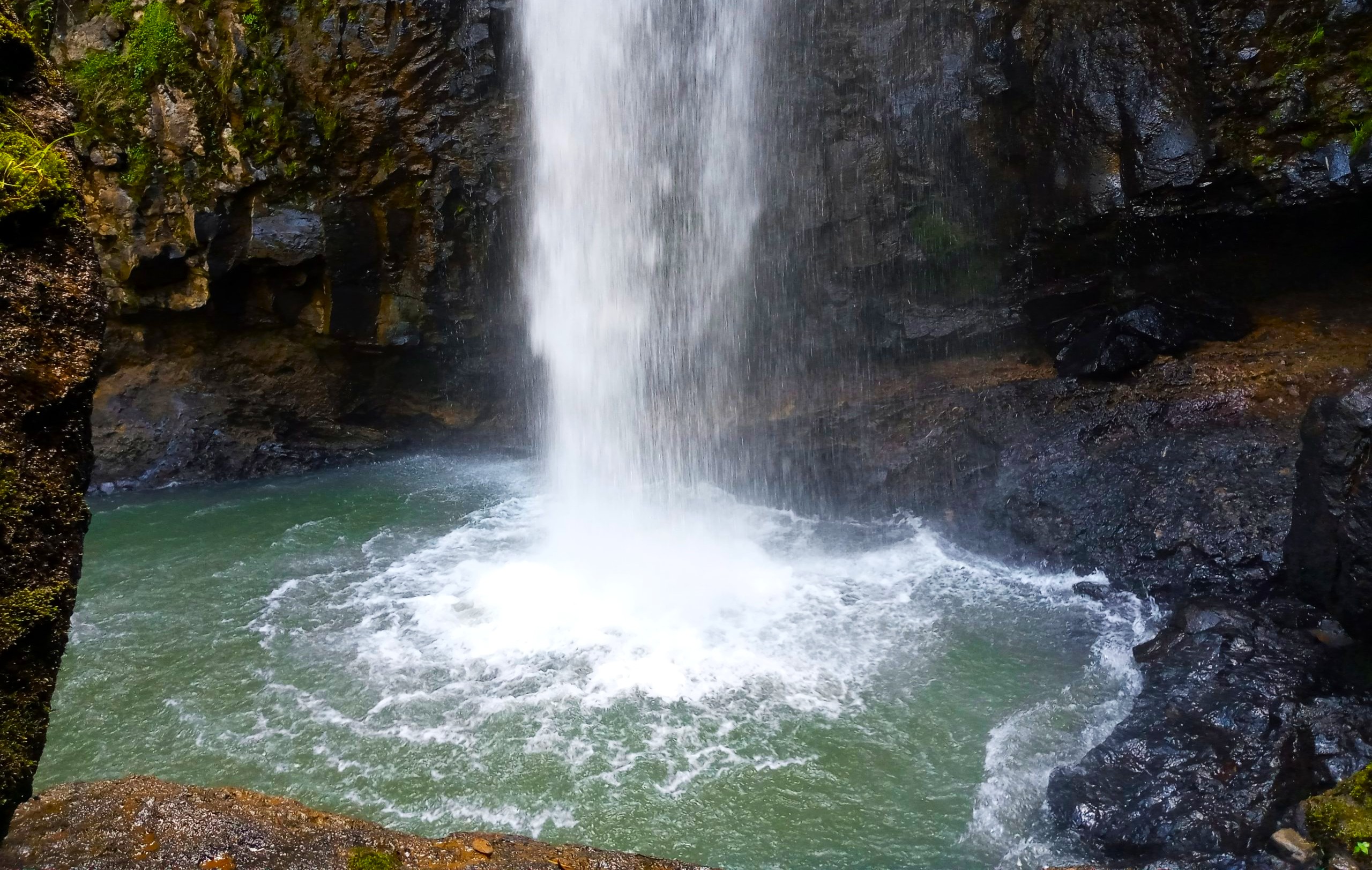
4. Waterfall No. 18 - The Descent
The trail drops to the Sasumua River via the pipeline leaveway (the cleared corridor running alongside the water supply pipeline), then makes the first sharp descent to the river level. The descent is steep — guides have cut stair-like steps into the mud and rock on the approach. The gradient is slippery. This is the section that makes the difficulty rating honest. At the bottom, the waterfall appears.
Waterfall No. 18 is the first of two named falls on the circuit — the numbering comes from the KFS survey of waterfalls within the Aberdare Forest Reserve. It drops onto the Sasumua River rocks in a wide, powerful cascade. Standing beneath it is loud. On clear days, the spray catches the light. You can dip your feet — or swim — in the pool at its base.
5. The Mau Mau Caves - Where Kenya Was Made
From Waterfall No. 18, the trail climbs briefly before arriving at the cave system above the river. These caves — natural rock overhangs and chambers in the cliff face — were operational bases for Mau Mau fighters from 1952 onward. Field Marshal Dedan Kimathi, the overall commander of the Kenya Land and Freedom Army, coordinated units across the Aberdare and Mount Kenya forests from positions like this. General China (Waruhiu Itote), who led operations specifically in the forests of Mount Kenya and the southern Aberdares, used the cave network for shelter, planning, and concealment.
The cold of the forest, the sound of the waterfall masking all movement, and the complete impenetrability of the bamboo to any vehicle or organised troop — these features made the Aberdare forests the most defensible terrain available to the fighters. The British colonial forces, operating in the lowlands, struggled to penetrate the bamboo at all.
Your guide will stand at the caves and tell you what happened here. Not the Wikipedia version. The version that comes from growing up within walking distance of where it happened.
6. General China Falls — The Second Waterfall
Past the caves, the trail descends again to the second waterfall — a cascading drop named after the general whose territory this was. It is visible from adjacent rocks above the fall line. The sound from the first waterfall follows you here. Two waterfalls in one circuit, connected by a trail that passes through a cave system used in Kenya's liberation war, in a bamboo forest where elephants still walk the same paths the fighters walked.
The trail then leads out through the bamboo and forest road back to China Camp Gate and the Sasumua Dam. The whole circuit takes 6 to 7 hours.
🕐 Full Day Itinerary - Hour by Hour
🚐 05:30 - Nairobi Departure
Wild Springs departs from Nairobi at 05:30 AM from the agreed pickup point. The drive follows Waiyaki Way onto the A104, turning off at Flyover onto the C67 Magumu-Njabini road. The road climbs into the highlands. By the time you reach the forest edge, the city temperature is a memory.
Self-drive option: Safe parking is available at the Sasumua Dam gate. Drive via A104 and turn onto C67 at Flyover. Follow signs for Njabini. The Ragia Forest Station at Sasumua is signposted. GPS: -0.9050, 36.5760. Arrange to meet your guide at the gate.
📋 08:00 - Sasumua Gate and KFS Registration
KFS registration and fee payment at the Ragia Forest Station. Your guide briefs the group on the trail sections, safety protocol for elephant country, and the historical context of what you are entering. This is not a polished heritage site. There are no signboards at the caves. The knowledge lives with the guide.
🎋 08:30 - China Camp Gate and Bamboo Tunnel
Trail begins. The bamboo closes around you within 200 metres.
🏗️ 10:00 - The Colonial Bridge, Sasumua River
Midtrail rest point at the 1952 colonial bridge. The pipeline corridor runs beside the trail from here.
💧 11:00 - Descent to Waterfall No. 18
The steep descent section. Take your time. The guides have cut steps. Muddy boots are guaranteed.
🕳️ 12:00 - Mau Mau Caves
Lunch break at or near the caves. Your guide tells the history. This is the reason Ragia is unlike any other forest trail near Nairobi.
🌊 13:00 - General China Falls
Second waterfall. Rest, photograph, swim if you choose.
🌿 14:00 - Return Through Bamboo and Forest Road
The return is easier in terrain but long in distance. The bamboo on the way back looks different in the afternoon light.
🚐 17:00 - Gate Return and Nairobi
Gate by 17:00. Nairobi by 19:30.
🌿 Flora - What Grows in Ragia Forest
Ragia's 4,250 hectares hold three distinct forest communities — the indigenous highland forest, the bamboo belt, and the plantation zones - each with its own plant assemblage.
Ragia Indigenous Forest (natural forest zone, 17km²)
Dominated by Podocarpus latifolius (Broad-leaf Yellowwood) and Nuxia congesta (Forest Elder) in the upper canopy. Lianas connect the old growth trees. Ferns — particularly on the cliff faces above the waterfalls — are extraordinarily dense. The rock faces around the caves support liverworts, mosses, and hanging fern communities that indicate permanently moist microhabitats.
Ragia Waterfalls Hike Bamboo Belt (Yushania alpina)
The bamboo is the dominant character of this trail. Yushania alpina (Ethiopian Highland Bamboo) grows in continuous stands through the mid-elevation sections — the same bamboo species found in the Bwindi Impenetrable Forest in Uganda and the mountain gorilla habitat zones. At Ragia, its density is such that it functions as a tunnel, not a forest edge. Sunlight reaches the trail floor only where wind has opened gaps in the canopy.
Waterfall Margins
The banks of the Sasumua River around both waterfalls support a distinct riparian plant community — tree ferns (Cyathea spp.), sedges, and a high diversity of herbaceous plants adapted to permanently wet, spray-influenced conditions. The fern coverage around Waterfall No. 18 is exceptional — tall tree ferns against the cliff backdrop create the most photogenic composition on the circuit.
🦁 Wildlife — What Lives in Ragia
| 🐾 Species | 👁️ Likelihood | 📍 Where | Note |
|---|---|---|---|
| 🐘 Forest Elephant | ★★★★☆ | Bamboo zone, elephant trails | Fresh sign common — active population |
| 🐒 Black-and-White Colobus | ★★★★☆ | Forest canopy throughout | Reliable in the indigenous forest section |
| 🐒 Olive Baboon | ★★★☆☆ | Forest margins and glades | Groups visible near the dam area |
| 🦌 Forest Duiker | ★★★☆☆ | Dense forest and bamboo margins | Often seen at dawn and dusk |
| 🐆 Serval Cat | ★★☆☆☆ | Forest clearings | Present — rarely seen |
| 🦔 African Porcupine | ★★☆☆☆ | Ground level throughout | Nocturnal — tracks visible |
| 🦌 Bushbuck | ★★★☆☆ | Forest glades and margins | Common in the indigenous forest |
Elephant safety note: This is active elephant country. Guides read fresh sign before proceeding on the bamboo section. Fresh dung, broken bamboo, and ground disturbance all indicate recency of elephant activity. The guide's instructions on elephant protocol are part of the opening briefing. It is not a precaution - it is a protocol you follow.
🔭 Birding — Ragia Forest
Ragia is within the southern Aberdare forest system — a recognised Important Bird Area. The mix of bamboo, indigenous forest, waterfall margins, and open glades creates multiple distinct micro-habitats in a single circuit.
- Abbott's Starling (Poeoptera femoralis) — globally threatened; Ragia is confirmed habitat. One of Kenya's most sought-after range-restricted species. The indigenous forest section above the bamboo is the primary habitat.
- Bar-tailed Trogon (Apaloderma vittatum) — one of Africa's most beautiful forest birds. Present in the dense indigenous forest. Often stationary and overlooked.
- Hartlaub's Turaco — the distinctive crimson wing flash in the canopy is unmistakable in the upper forest section.
- African Crowned Eagle — Ragia's forest is old-growth enough to support nesting. Occasionally seen soaring above the forest edge.
- African Emerald Cuckoo — melodious call throughout the forest. Often heard before the waterfall drowns it out.
- Various Sunbird Species — active at the forest margins and along the pipeline leaveway where flowering plants are accessible.
- Cinnamon-chested Bee-eater — active on exposed perches at the forest edge.
Log your sightings at the Aberdare South eBird hotspot.
🏛️ The Mau Mau History - In Full
This is the section no other operator bothers to write. You should read it before you go.
General China — Waruhiu Itote (1922-1993)
Waruhiu Itote was born in Nyeri District in 1922. He received minimal formal education before moving to Nairobi as a teenager. In 1942, he enlisted in the British Army — specifically the King's African Rifles — and served throughout Asia, including the Burma Campaign against Japanese forces. He was promoted to Corporal.
He returned to Kenya having seen how an empire operates in war. He took the Mau Mau oath in 1950 and, as the colonial government began clamping down in 1952, he entered the forests of central Kenya. He was among the first senior fighters to enter the forests in August 1952. He commanded a series of raids against white settler farms in Nyeri and led an insurgency that the colonial military found extremely difficult to contain.
He was given the nom de guerre General China. The name stuck. The gate. The camp. The waterfall. All are named after him.
He was captured on 15 January 1954 during a failed operation near a police post. Shot in the neck, taken alive. He was tried, sentenced to death, and eventually cooperated with British intelligence officer Ian Henderson, providing detailed accounts of the Mau Mau organisation in exchange for his life. His legacy remains controversial among Kenyans — a brilliant commander who survived by cooperation when others did not. He died in 1993.
His memoir, Mau Mau General (1967), is the primary first-person account of the forest operations. It is still in print.
Field Marshal Dedan Kimathi (1920-1957)
Kimathi was the overall commander of the Kenya Land and Freedom Army (KLFA) — the military wing of the Mau Mau. Where General China commanded specific operations in the Mt. Kenya and southern Aberdare zones, Kimathi coordinated strategy across multiple forest-based units spanning both mountain ranges.
In 1953, he established the Kenya Defence Council — a de facto high command for the entire forest-based guerrilla army. He combined political vision with military command in a way that made him the most significant figure in the armed independence struggle.
He was captured by British forces on 21 October 1956, wounded and hiding in the Aberdare forest. He was tried, convicted of illegal possession of a firearm, and hanged on 18 February 1957 at Kamiti Maximum Security Prison. He was 36 years old.
His statue stands at the intersection of Kimathi Street and Mama Ngina Street in Nairobi's CBD.
The caves at Ragia were one of dozens of operational positions across the Aberdare forest system used by the fighters Kimathi coordinated. Standing at the cave entrance above the Sasumua River, looking out at the bamboo that made these slopes nearly impenetrable to colonial troops, you are in one of the most specific locations where Kenya's independence was decided.
💰 2026 Pricing - Ragia Forest Waterfall Hike
All-inclusive. KFS entry fees handled. Nothing added at the gate.
| 🇰🇪 Kenyan Citizens | 🌍 EAC Residents | 🌐 International |
|---|---|---|
| KES 4,950 per person | KES 4,200 per person | $80 per person |
Group discounts apply for 6+ people. Contact us for private group quotes.
| 👥 Group Size | 🇰🇪 Kenyan Citizens | 🌐 Non-Residents |
|---|---|---|
| 1–2 Persons | KES 9,500 pp | $75 pp |
| 3–5 Persons | KES 8,800 pp | $65 pp |
| 6–10 Persons | KES 5,500 pp | $60 pp |
| 11–20 Persons | KES 4,9520 pp | $55 pp |
📌 Deposit: 30% confirms booking
📌 Cancellation: Full refund with 48 hours' notice
📱 M-Pesa Paybill: 4065921 · Account: "Ragia"
✅ What Is Included
- ✔ 🚐 Round-trip transport from Nairobi — CBD or Westlands pickup
- ✔ 🎫 KFS Ragia Forest Station entry fees — all participants
- ✔ 🧭 Experienced Wild Springs forest guide — Ragia circuit specialist
- ✔ 🍱 Trail snacks and drinking water
- ✔ 🩺 Emergency first aid kit
- ✔ 🚁 AMREF Flying Doctors emergency evacuation cover — all participants, all day
❌ What Is Not Included
- ✗ Personal hiking gear — waterproof boots, gaiters, rain jacket, trekking poles
- ✗ Personal lunch (bring your own or we arrange — advise at booking)
- ✗ Guide and camp tips — KES 500–1,000 suggested
- ✗ Travel insurance — strongly recommended
- ✗ Transport if self-driving — parking available at gate
🏢 Ragia Forest - Corporate Team Building
The Forest Where Hierarchy Disappears
Ragia has a quality that office parks and conference centres have spent decades trying to replicate: it levels people. The bamboo tunnel narrows the group. The elephant trail protocols require everyone to follow the guide's pace — there is no overtaking. The descent to the waterfall demands mutual support at the slippery sections. And the Mau Mau cave briefing — standing where it actually happened — lands differently on people who have spent the morning working together to get there.
What makes Ragia specifically effective for corporate groups:
The historical debrief at the Mau Mau caves is the most effective team-building facilitation moment in any Nairobi day trip. Your guide talks about what General China's forest units required to function: clear communication across units that could not see each other, absolute trust in the person in front, shared hardship creating collective purpose, and decisions made fast in conditions where the wrong one was final. None of this needs to be translated to a corporate context. The team makes the connection themselves.
Corporate Team Building Pricing — Ragia Forest
| 👥 Team Size | Format | Price Per Person |
|---|---|---|
| 8 to 15 persons | Private guided — minibus + guide | KES 4,500 pp |
| 16 to 25 persons | Private guided — coach + guide | KES 3,800 pp |
| 26 to 40 persons | Full corporate day with facilitation | KES 3,200 pp |
| 40+ persons | Quote on request | WhatsApp us |
Corporate package includes: Private vehicle, experienced guide, KFS entry fees, trail snacks and water, AMREF evacuation cover, and post-hike group debriefs structure.
Available every day, including weekends. Minimum 48 hours advance booking.
📬 Request corporate quote · View all team building packages
⚠️ Safety and Trail Notes
The descent is genuinely slippery. The section from the pipeline leaveway down to Waterfall No. 18 is steep, muddy, and involves rock sections that become near-glassy when wet. Guides have cut stair-like steps into the mud. This is the most technically demanding section of the trail and the main reason the difficulty is rated Moderate to Hard. Waterproof boots with grip are not optional.
This is active elephant country. Fresh elephant sign — dung, broken bamboo, disturbed ground — is common on the bamboo section. Your guide reads this sign and makes protocol decisions accordingly. Follow the guide's instructions without discussion. Ragia elephants are forest elephants — smaller than plains elephants but as unpredictable in dense bamboo.
The river crossings can be challenging after heavy rain. The Sasumua River at the waterfall base and the smaller crossings on the trail vary significantly with rainfall. Tell your guide if you have difficulty with water crossings. This is not a liability question — it is a safety planning question.
Photography at Sasumua Dam is restricted by government protocol. Do not photograph the dam infrastructure.
The trail is off the beaten path. Ragia has no formal trail infrastructure — no boardwalks, no barriers, no signboards at the caves. This is part of what makes it authentic. It is also why you come with a guide.
🎒 What to Bring for Ragia Hike
Essential - no shortcuts:
- 🥾 Waterproof hiking boots with grip soles — the descent requires them
- 🧥 Light rain jacket — forest weather changes fast
- 👖 Long trousers — bamboo trail edges and undergrowth
- 💧 2+ litres of water — the circuit is longer than it looks
- 🍫 Energy food — snacks, bars, nuts — lunch is late
- 📱 Fully charged phone or camera — the colonial bridge and waterfalls reward photographs
- 🔦 Headtorch — in case the circuit runs longer than planned
Strongly recommended
- 🧤 Lightweight gloves — for grip on slippery descent sections
- 🦵 Gaiters — mud on the descent is deep
- 🧗 Trekking poles — the steep sections are significantly easier with them
🏪 Full gear available at the Wild Springs Outdoor Store.
📅 Best Time to Hike Ragia Forest
| Month | Conditions | Trail State |
|---|---|---|
| January to March | ⭐⭐⭐⭐⭐ Ideal | Firm, waterfalls at good volume |
| April to May | ⭐⭐ Avoid if possible | Very slippery on descent, bamboo floor wet |
| June | ⭐⭐⭐ Good | Improving |
| July to September | ⭐⭐⭐⭐⭐ Ideal | Best conditions — firm, clear forest |
| October | ⭐⭐⭐ Variable | Short rains begin |
| November | ⭐⭐⭐ Manageable | Wet but not impassable |
| December | ⭐⭐⭐⭐ Good | Rains easing |
Waterfall volume note: The waterfalls are most powerful and most dramatic in October-November and April, when rainfall is highest. However, the trail condition deteriorates significantly in wet season. The January-March window gives a good waterfall volume with manageable trail conditions.
🌿 Leave No Trace - KFS Forest Reserve Rules
Ragia is a Kenya Forest Service gazetted forest reserve — part of Kenya's legally protected water tower system. These are legal conditions of entry.
- 🗑️ All waste exits with your group - nothing left in the forest
- 🌿 No plants, seeds, or biological material removed
- 🔥 No fires in the forest reserve
- 🐘 Do not approach or provoke wildlife — follow guide instructions immediately
- 📷 No photography of Sasumua Dam infrastructure — government restriction
- 🚗 No vehicles beyond the designated parking area at the gate
We read these conditions aloud at the pre-hike briefing on every trip.
🔗 Related Hikes From Nairobi
| Trail | Distance | Difficulty | Best For |
|---|---|---|---|
| 🐘 Elephant Hill | 7–10 hrs | Hard | Northern neighbour of Ragia — do both |
| 💧 Seven Ponds Aberdares | 7–9 hrs | Challenging | Alpine ponds, 3,826m |
| 🗻 Table Mountain Aberdares | 7–9 hrs | Hard | Wildflower glade, hidden cliff views |
| 🏅 Mount Satima | 5–8 hrs | Moderate–Hard | Highest Aberdare, Dragon's Teeth |
| 🏔️ 3-Day Aberdare Safari | 3 Days | Various | Karuru Falls, bongo, camping |
📞 Book Your Ragia Forest Waterfall Hike
Daily departures. Private groups run with 48 hours' notice. Self-drive parking available at the gate.
📱 WhatsApp (fastest): +254 729 257 317 · +254 734 417 496
📱 M-Pesa Paybill: 4065921 · Account: "Ragia"
🌍 For Our International Guests
🇩🇪 Deutsch: Tageswanderung im Ragia-Wald — zwei Wasserfälle, Mau-Mau-Höhlen von General China und Feldmarschall Dedan Kimathi, koloniale Brücke von 1952 und dichter Bambuswald, 90 km von Nairobi. Geführte Wanderung ab KES 3.500 pp. WhatsApp: +254 729 257 317 · Österreich: +43 650 702 1313
🇫🇷 Français: Randonnée d'une journée dans la forêt de Ragia — deux chutes d'eau, grottes Mau Mau du Général China et du Maréchal Dedan Kimathi, pont colonial de 1952 et forêt de bambous dense, à 90 km de Nairobi. Excursion guidée à partir de KES 3.500 pp. WhatsApp : +254 729 257 317
🇪🇸 Español: Senderismo de un día en el bosque de Ragia — dos cascadas, cuevas Mau Mau del General China y el Mariscal Dedan Kimathi, puente colonial de 1952 y denso bosque de bambú, a 90 km de Nairobi. Excursión guiada desde KES 3.500 pp. WhatsApp: +254 729 257 317
Where You Will Visit
This safari explores the following regions in Kenya
- Geta Bush, Nyandarua County