🦋 Mount Kipipiri -The Butterfly Mountain Wanjohi Valley, Aberdare Range Kenya
Safari at a Glance
Wild Springs Adventures | 📍 Geta Forest Station, Nyandarua County
🌋 The Mountain That Stands Alone
Every other peak in the Aberdare Range connects to its neighbours — a continuous ridge of volcanic highland running north to south through central Kenya. Mount Kipipiri does not. It rises alone from the Wanjohi Valley, a dormant volcanic cone that broke free from the main massif through millions of years of erosion and tectonic movement, leaving it stranded on the Kinangop Plateau like a sentinel facing the rest of the range across an open valley.
From a distance, the mountain's silhouette is distinctive enough that the Gikuyu people named it Kipipiri — meaning "butterfly" — for the shape its profile makes against the sky. That name has stuck for generations, and it fits. Kipipiri does not look like the other Aberdare peaks. It does not behave like them either.
While Elephant Hill and Rurimeria send hikers straight up steep bamboo ridges, Kipipiri takes you through a long, undulating traverse — from the Geta Forest Station on the southeast slopes, through meadows of wildflowers and indigenous forest, up to a summit crowned by a distinctive large rock, and down the other side to Miharati on the northwest. It is one of the only Aberdare trails where you start and finish at different points. You walk through the mountain rather than up and back down the same face.
At 3,349 metres above sea level, Kipipiri is more accessible than Rurimeria, gentler in gradient than Elephant Hill, and significantly less crowded than either. The trail is growing in popularity — but slowly. You can still have sections of it entirely to yourself. That is increasingly rare on the Aberdares.
And under its slopes sits the Wanjohi Valley — a place with a history that is equal parts scandalous, colonial, and quietly remarkable. The people who once called this valley home gave the world the phrase: "Are you married, or do you live in Kenya?"
🎯 The honest truth:
Kipipiri is often described as the easiest Aberdare hike. That is misleading. The distance alone — up to 21km point-to-point — demands real endurance. The altitude gain of ~849m is gradual but sustained. The weather can change as fast as on any other Aberdare peak. What Kipipiri genuinely offers that others don't is variety: changing forest types, open meadows, wildflowers, river crossings, summit views in four directions, and a history layered into the very valley you walk above. It is the Aberdare trail for people who want more than a summit — they want a story.
📋 Mount Kipipiri Trek at a Glance
| ⛰️ Summit | Mount Kipipiri, 3,349m (10,988ft) |
| 📈 Elevation Gain | ~849m (2,785ft) from Geta trailhead |
| 📏 Distance | 21km one-way traverse (Geta → Miharati) or 9–12km out-and-back |
| ⏱️ Time on Trail | 8–9 hours (traverse) / 6–7 hours (out-and-back) |
| 📍 Trailhead | Geta Forest Station, Nyandarua County |
| 🗓️ Trailhead Altitude | 2,500m (8,200ft) |
| 🏁 Finish Point | Miharati (traverse) or back to Geta (out-and-back) |
| 💪 Difficulty | Moderate — long but gradual; accessible to fit hikers |
| 🛣️ Distance from Nairobi | ~130km (approx. 3–3.5 hrs including rough murram road) |
| 🌳 Permit | Kenya Forest Service (KFS) — collected at Geta gate |
| 🪖 Guide Requirement | Armed forest guard + certified guide — mandatory |
🏛️ The Valley Below — A History Unlike Any Other
The Wanjohi Valley stretching below Kipipiri's slopes is better known by a different name: Happy Valley.
From the 1920s through the 1940s, a small but extraordinarily colourful community of wealthy British settlers turned this remote highland valley into one of colonial Africa's most infamous playgrounds. The Valley's residents — aristocrats, adventurers, and escapees from European convention — held lavish parties that rotated from estate to estate, lived openly scandalous lives, and gave rise to a culture of decadence so extreme it shocked even British colonial society. The famous joke of the era — "Are you married, or do you live in Kenya?" — was born here.
The heart of Happy Valley was a house called Clouds, near Kipipiri's slopes, where the social scene centred. It was here that Josslyn Victor Hay, the 22nd Earl of Erroll, was found shot dead in his car in January 1941 — a murder that was never conclusively solved, and which drew the eyes of the world to this remote Kenyan valley. The story was retold in James Fox's book White Mischief and later adapted into a film.
After Kenyan independence in 1963, landless Kenyans were resettled on the mountain's lower slopes. The upper regions were declared a forest reserve under the Kenya Forest Service (KFS), and an electric fence was built to protect the remaining indigenous forest. Some of the former settler houses still stand — including the house of Alice de Janzé, now a school, and Patricia Bowel's former home, now belonging to the Catholic Church.
You hike above all of this. The valley and its stories are visible from every viewpoint on the way up.
🕐 The Full Day — Hour by Hour
🚐 04:30 – 05:00 · Nairobi · Departure
The drive to Kipipiri is longer than Elephant Hill — about three hours, including a rough stretch of murram road. You leave in the dark. By the time you reach Njabini town and turn toward Ndunyu Njeru and Geta, the sun is rising over the Aberdare Range to your right. The last 12km to the gate is unpaved, slow, and completely worth it — the views of Wanjohi Valley opening up below you are the first reward of the day.
📋 08:00 – 08:30 · Geta Forest Station, 2,500m · Briefing & Start
KFS permits paid at the gate. Your armed forest guard and certified guide join the group. Boots laced. Quick briefing on the route, the wildlife, and the turnaround protocol. The morning is usually clear here. You can see the main Aberdare ridge across the valley. Then you turn and look up at Kipipiri. It looks bigger than it is. That is both reassuring and deceptive.
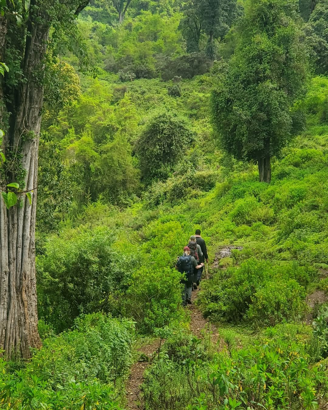
🌳 08:30 – 10:30 · 2,500m – 2,800m · Plantation Forest & Open Meadows
The trail starts on wide tractor tracks used by forestry teams harvesting timber from the lower plantation slopes. Pine and cypress on both sides. Flat, easy, deceptive. After about 30 minutes these tracks end and the path narrows into animal trails. The ground transitions from packed earth to meadow grass, and the first wildflower beds begin. River crossings appear — small, clear highland streams, cold enough to wake you up if you slip. You can see houses, farms, and fences down in the Wanjohi Valley below, and the green slopes of the Happy Valley farms. Stop at the rocky viewpoint halfway up — it is one of the best panoramic shots on the entire trail.
🌿 10:30 – 12:30 · 2,800m – 3,100m · Indigenous Forest & Wildflower Meadows
Two hours in, the plantation gives way to proper indigenous forest. The canopy closes, the undergrowth thickens, the light changes. The trail occasionally dips under the canopy for a hundred metres, then emerges into open grassland meadows again — the most visually varied hiking experience of any Aberdare trail. Wildflower beds cover the open sections in purple, gold, and white. Colobus monkeys move through the canopy — their explosive whooping calls carry far through the forest.
⚠️ Altitude effects can start here. You are above 2,800m and the gradient is gradual but continuous. Breathe steadily. Drink water. Do not rush this middle section.
🌾 12:30 – 14:00 · 3,100m – 3,349m · Moorland, Tussock & Summit Rock
The forest thins. Tussock grass takes over, with marshy sections where the ground gives under your boots — step on the grass clumps, not between them. Giant Lobelia (Lobelia deckenii) appears at the trail's edge. The gradient flattens slightly. Then you see it: a conspicuous large rock rising from the moorland — the actual summit of Mount Kipipiri. The final scramble is short and non-technical. You pull yourself up on solid volcanic basalt and stand on top.
🏆 14:00 · 3,349m · THE SUMMIT — Four Directions, Four Views
To the north: Lake Ol Bolosat — Kenya's only natural freshwater lake on the floor of the Rift Valley, shimmering like a mirror. To the west: Lake Naivasha, visible from 32km away, with Mount Longonot's volcanic cone beside it. To the east: the full ridge of the Aberdare Range — Rurimeria, Table Mountain, Satima — laid out like a map. To the south: the Wanjohi Valley and the faint shapes of the Happy Valley houses. This is not a crowded summit. You may have it to yourself.
⬇️ 14:30 – 17:30 · 3,349m → 2,430m · Descent to Miharati
The traverse route descends northwest — steeply at first through forested sections, then more gently through farmland as you cross the electric fence and emerge onto tarmac at Miharati town on the Njabini–Ol Kalou road. Descent takes 3–4 hours. Wild Springs vehicles meet you here. At Miharati, there is also public transport back toward Nairobi if needed.
🗺️ The Four Trail Sections
🌳 Section 1 · 2,500m – 2,800m · Plantation Forest & Meadows Wide tractor tracks through pine and cypress, transitioning to animal trails across open meadow with river crossings and first valley views. Gentle and gradual. The trail lulls you.
🌿 Section 2 · 2,800m – 3,100m · Indigenous Montane Forest The most botanically rich section on the Aberdares. Indigenous montane trees replace plantation, wildflower beds alternate with forest canopy, and Colobus monkeys in the upper branches. The most beautiful two hours of hiking on the range.
🌾 Section 3 · 3,100m – 3,349m · Moorland & Tussock Tussock grassland, marshy sections, Giant Lobelia. The summit rock becomes visible. The air thins. Walk on grass clumps, not between them.
🏆 Section 4 · 3,349m → 2,430m · The Summit & Descent to Miharati Summit rock scramble, four-direction views, then steep descent through forest and farmland to Miharati on tarmac.
🌸 Flowers & Plants Along the 🦋 Mount Kipipiri Trail
Kipipiri has the most visually varied plant life of any Aberdare hike — because the point-to-point traverse crosses more ecological zones than any other single-day trail on the range.
On the plantation slopes, you walk through Pinus radiata and Cupressus lusitanica — trees the colonial forestry service introduced in the 1940s, now towering and fragrant. As the trail enters the indigenous zone, this gives way suddenly to one of the finest examples of East African montane forest in the Aberdares. African pencil cedar (Juniperus procera) — a species with deep cultural significance to the Gikuyu, used in traditional ceremonies — forms the upper canopy alongside East African camphor (Ocotea usambarensis) and podo (Podocarpus latifolius). Some cedars on Kipipiri are hundreds of years old.
In the open meadow sections between forest patches, the trail passes through expansive wildflower beds that most hikers are completely unprepared for. Helichrysum spp. — the everlasting flowers — grow in cream and gold clusters across the open slopes, retaining colour months after drying. Red-hot pokers (Kniphofia spp.) stand in flame-orange columns at the meadow edges. Wild orchids appear in wetter drainage channels — small, easily missed, and extraordinary. The Aberdare Range holds 778 recorded plant species, and the Kipipiri Forest Reserve contributes a significant number of rare and endemic members.
On the upper moorland, Lady's Mantle (Alchemilla hageniae) — an Aberdare endemic — carpets wet sections, its lobed leaves cupping morning dew in perfect spheres. Giant Lobelia (Lobelia deckenii) lines the trail as you approach the summit. On the summit rock itself, Dendrosenecio battiscombei — the giant groundsel unique to the Afro-alpine zone of East Africa's high mountains — grows in small clusters. On Kilimanjaro, they are a famous sight. On Kipipiri, they are a quiet surprise.
🦁 Wildlife & Nature
The 43 km² Mount Kipipiri Forest Reserve sits within the larger Aberdare National Park ecosystem, connected to the main range by a wildlife corridor negotiated in June 2009. At road crossings through the corridor, rolling bar grids replace fences — an obstacle wildlife will not attempt, but cars can cross. This keeps animals in and most poachers out.
| 🐾 Species | 👁️ Likelihood | 📍 Where | 📝 Note |
|---|---|---|---|
| 🐘 Forest Elephant | ★★★☆☆ | Lower forest zones | Present via the wildlife corridor. Tracks are regular; sightings real. The armed guard exists for this reason. |
| 🦬 Buffalo | ★★★☆☆ | Forest & meadow edges | Often in groups; generally move away from noise |
| 🐒 Black-and-White Colobus | ★★★★★ | Indigenous forest section | One of the most reliable Colobus trails in Nyandarua. Almost guaranteed. |
| 🐒 Sykes' Monkey | ★★★★☆ | Forest canopy | Often seen alongside Colobus in mixed groups |
| 🦌 Bushbuck | ★★★☆☆ | Forest edges & meadows | Often seen at dusk on descent |
| 🐆 Leopard | ★★☆☆☆ | Rocky sections, upper forest | Presence confirmed; direct sightings rare |
| 🐦 200+ Bird Species | ★★★★★ | All zones | See birding section below |
🔭 Birding on Mount Kipipiri — A Reason to Come by Itself
Kipipiri and the surrounding Kinangop Plateau are among East Africa's most significant birding landscapes — and among its least visited. The combination of the mountain's diverse forest zones and the plateau grasslands below creates a birding double: highland forest specialists on the trail, and grassland endemics in the valley on the way home.
The Kinangop Plateau is a designated Important Bird Area (IBA) by BirdLife International, and is the global stronghold of one of Kenya's rarest birds.
On the mountain:
- Jackson's Francolin (Pternistis jacksoni) — near-endemic to Kenya's central highlands, regularly heard and seen in the forest transition zone
- Hartlaub's Turaco — one of Africa's most beautiful birds- lives in the indigenous forest section; you will hear it before you see it
- Golden-winged Sunbird (Drepanorhynchus reichenowi) — common in the wildflower meadows, following the Helichrysum and Lobelia flowering cycle
- Mountain Buzzard and Augur Buzzard — soaring above the moorland on the upper trail
- Bar-tailed Trogon — a forest gem of the indigenous zone, one of the most sought-after birds in Kenya
On the Kinangop Plateau (drive home):
- Sharpe's Longclaw (Macronyx sharpei) — a Kenyan endemic classified as Endangered by the IUCN Red List. Fewer than 19,000 individuals remain worldwide. The Kinangop Plateau is its single most important remaining stronghold. Ask your driver to stop at the grassland sections near Engineer and Njambini for a chance at one of the rarest birds in Kenya — this addition to the day costs nothing extra and takes 45 minutes.
- Jackson's Widowbird (Euplectes jacksoni) — near-endemic, spectacular in breeding plumage, November through March
- Kikuyu White-eye — common in hedgerows on the descent to Miharati
Log your sightings at the Aberdare National Park eBird hotspot. The Kipipiri traverse is consistently one of the most species-diverse single-day lists birders submit from the Aberdares.
💰 🦋 Mount Kipipiri Trek Pricing 2026
No surprise charges at the KFS gate. All costs below are complete.
| 🇰🇪 Kenyan Citizens | 🌍 East African Residents | 🌐 International |
|---|---|---|
| KES 4,999 per person | KES 5,700 per person | USD 99 per person |
Group discounts apply for 5+ people. Contact us for a private group quote.
✅ What's Included
- 🚐 Round-trip transport from Nairobi (CBD/Westlands pickup)
- 🌳 KFS Forest Reserve entry fees
- 🪖 Armed KFS forest guard for the full traverse
- 🧭 Certified Wild Springs mountain guide
- 🍱 Packed lunch and trail snacks
- 💧 Drinking water
- 🩺 Emergency first aid kit and evacuation support
- 🚗 Vehicle at Miharati to collect traverse groups
❌ Not Included
- 👟 Personal hiking gear: boots, gaiters, warm layers
- 🙏 Guide & guard tips (KES 1,000–2,000 suggested)
- 🛡️ Travel insurance (strongly recommended)
- 🗺️ Optional overnight camping extensions
🎒 What to Bring Mount Kipipiri Hiking
🥾 Footwear & Lower Body
- Waterproof hiking boots with ankle support — the trail crosses rivers and has marshy moorland sections
- Gaiters — the tussock moorland is wet and the grass hides ankle-rolling gaps
- Long trousers — the indigenous forest undergrowth is thick
- Two pairs of hiking socks — one dry pair kept in the bag
🧥 Clothing Layers
- Moisture-wicking base layer — no cotton
- Insulating mid-layer — fleece or lightweight down
- Waterproof shell — Kipipiri's weather is as unpredictable as any Aberdare peak
- Warm hat and gloves for the summit section
- Sun hat — the open meadow sections have no shade
🎒 Gear & Food
- Trekking poles — the river crossings and descent to Miharati reward having them
- 3 litres of water minimum — no reliable sources above the lower forest
- Packed lunch and high-energy snacks
- Camera with enough storage — the wildflower meadows alone will fill a memory card
- Binoculars — essential for the birding, especially the Kinangop stop on the way home
- Headlamp with spare batteries
- Sunscreen SPF 50+
- Personal first aid: blister pads, paracetamol, personal medication
🏪 Gear available at the Wild Springs Outdoor Store. Our lead guide Tim offers free kit advice for this specific trail.
⚠️ Safety on This Trail
⚠️ Distance Underestimation
The traverse is 21km. Many hikers who have only done Elephant Hill arrive expecting a similar distance. Kipipiri is longer. The gradual gradient masks the accumulation of fatigue. Pace yourself from the first hour — the last 5km to Miharati are long and steep.
⚠️ Navigation on Upper Moorland
Trail markers thin out above the treeline. Tussock grass can obscure the path and fog arrives quickly at altitude. Your certified guide knows the route well — do not get ahead of or separated from the group.
⚠️ River Crossings
Four or five small river crossings on the lower section can run ankle-deep after rain. Gaiters and waterproof boots are not optional here — they are the difference between a wet, miserable second half of the day and a comfortable one.
⚠️ Wildlife — Elephants via the Corridor
Since the 2009 wildlife corridor was established, elephant movement between Kipipiri and the main Aberdare has increased. Your armed forest guard is there because this threat is real. Stay together. Move quietly in the lower forest zones.
⚠️ Time Management — Rough Road Home
The drive back from Miharati includes 12km of murram road. Plan to be at Miharati by 17:30 to allow for the 3+ hour drive home.
📅 Best time to Go Hiking 🦋 Mount Kipipiri
Dry seasons give the clearest summit views and most reliable trail conditions. In the rainy seasons, river crossings deepen, but the wildflower meadows are at their absolute peak — a trade-off worth knowing about before you book.
| 📆 Month | ⭐ Conditions |
|---|---|
| January | ⭐⭐⭐⭐⭐ Ideal — dry, clear four-direction summit views |
| February | ⭐⭐⭐⭐⭐ Ideal — best visibility of the year |
| March | ⭐⭐⭐ Okay — trail wets up, wildflowers begin |
| April | ⭐⭐ Avoid — long rains, river crossings deepen |
| May | ⭐ Avoid — heaviest rain, serious trail hazard |
| June | ⭐⭐⭐⭐ Good — dry season opens |
| July | ⭐⭐⭐⭐⭐ Ideal |
| August | ⭐⭐⭐⭐⭐ Ideal — peak birding season, clear views |
| September | ⭐⭐⭐⭐ Good |
| October | ⭐⭐⭐ Variable — short rains can begin |
| November | ⭐⭐ Risky — wildflowers at their best but trail muddy |
| December | ⭐⭐⭐⭐ Good — rains ease off |
Birding note: August to October is the most diverse bird season on the Kinangop Plateau. For Sharpe's Longclaw specifically, March–June and September–October are breeding season — best for sightings and display behaviour.
➕ Extensions & Custom Options
🏕️ Overnight Camping The traverse is long enough that some groups prefer to camp near the summit or in the upper forest and descend fresh the next morning. KFS can advise on approved campsites. Wild Springs can organise camping equipment. Enquire in advance.
🔭 Birding Add-On — Kinangop Plateau Grasslands Add a 2–3 hour stop on the Kinangop Plateau between Miharati and Nairobi, specifically targeting Sharpe's Longclaw, Jackson's Widowbird, and the Kikuyu White-eye. This add-on transforms the day into one of the best endemic birding experiences within 3 hours of Nairobi. Contact us to discuss timing and locations.
🏛️ Happy Valley Heritage Drive Combine the Kipipiri hike with a historical drive through the Wanjohi Valley — including the former estate sites of Happy Valley settlers. Available as a pre-hike evening activity for groups arriving the night before. Ask about accommodation options near Miharati.
📊 How Kipipiri Compares to Other Aberdare Trails
| 🏔️ Trail | ⬆️ Summit | 💪 Difficulty | 🎯 Best For | ⏱️ Time |
|---|---|---|---|---|
| ⭐ Mount Kipipiri | 3,349m | Moderate | Wildflowers, birding, Happy Valley history, traverse experience | 8–9 hrs |
| 🐘 Elephant Hill | 3,658m | Hard | First serious Aberdare challenge, training | 7–10 hrs |
| 🪨 12 Apostles | 3,672m | Very Hard | Extreme challenge, peak baggers | 12–14 hrs |
| 🗻 Table Mountain | 3,817m | Moderate | Scenic, photography, moorland walking | 5–7 hrs |
| 💧 Seven Ponds Trail | 3,826m | Hard | Glacial tarns, solitude | 7–8 hrs |
| 🦏 Rhino Hill | ~3,800m | Hard | Ridge traverse | 8–9 hrs |
| 🌾 Rurimeria Hill | 3,860m | Strenuous | Serious Mount Kenya training | 7–10 hrs |
| ⛏️ Kinangop | 3,906m | Hard | Technical, exposed ridges | 7–9 hrs |
| 🏅 Satima | 4,001m | Moderate | Highest Aberdare, gentler from north | 4–6 hrs |
Kipipiri is the ideal entry point for those who want genuine altitude and wilderness without the extreme difficulty of Elephant Hill or Rurimeria. It is also the only Aberdare trail with a clear point-to-point traverse option and a built-in history lesson.
Source: AllTrails — Aberdare National Park · Wild Springs guided records.
👥 Private & Custom Options
👥 Private Groups
Your date, your pace, no strangers. Kipipiri's trail is long enough that private groups can genuinely set their own rhythm — stopping for wildflowers, birding at the forest edge, sitting on the summit rock as long as the weather allows.
🏢 Corporate Teams
Kipipiri works exceptionally well for corporate groups who want a challenge without the extremity of Elephant Hill. The point-to-point format means you cannot turn back casually — you commit to the full traverse together. That shared forward motion is a powerful team dynamic.
🔭 Birding & Nature Groups
The combination of the traverse and a Kinangop Plateau grassland stop is one of the richest single-day nature experiences available within three hours of Nairobi. We can customise timing, stopping points, and pace for dedicated birding groups.
🎓 Schools & Youth Groups
Kipipiri's moderate difficulty and extraordinary wildflower sections make it the best Aberdare trail for school groups. The Happy Valley history adds an educational layer that classroom visits cannot replicate.
🤝 Why Wild Springs
- ⭐ TripAdvisor Award Winner — verified reviews from real hikers and climbers
- 🏛️ Kenya Tourism Authority Licensed — fully registered tour operator
- 🌍 TOSK Kenya Member — Tour Operators Society of Kenya
- 🧗 MCK Certified Guides — Mountain Club of Kenya
- 🤝 Fair Pay — guides and rangers paid above industry standard, always
- 🌿 Leave No Trace — zero plastic policy, all waste carried out, no fires on the mountain
🏔️ What Comes Next
Kipipiri is the gentlest starting point on the Aberdares — the one that builds confidence for bigger objectives.
- 🐘 Elephant Hill — next step up in difficulty, same region
- 🌾 Rurimeria Hill Moorland Trek — the serious training ground for Mount Kenya
- 📅 Mount Kenya Group Treks 2026 — fixed dates, spaces fill fast
- 💪 Mount Kenya Fitness Programme — 8-week structured training plan
- 🎒 Gear Checklist — what to buy, rent, and leave at home
- 🏪 Wild Springs Outdoor Store — boots, gaiters, trekking poles, base layers
💳 How to Book & Pay
📱 M-Pesa Paybill
- Paybill: 4065921
- Account: "Kipipiri"
After payment, WhatsApp your name, date, and group size to confirm your spot.
🏢 Cash at the Office
Valley View Office Park, Tower A, First Floor, Sixth Avenue Parklands, off Limuru Road, Nairobi
🦋 The Butterfly Mountain Is Waiting
Kipipiri runs every weekend throughout the dry season. It is the only Aberdare trail that gives you a history, a wildflower garden, a wildlife forest, and a summit with four different views — in a single day. Come for the hike. Stay for the stories.
📞 +254 729 257 317 · +254 734 417 496 · +254 721 957 652
Where You Will Visit
This safari explores the following regions in Kenya
- Njabini, Nyandarua County